That is 0 articles you have read today.
The Aporia is free and carries no advertising, so readers are the only
thing paying for it. If you are getting this much out of it, a small
donation is what keeps it independent.
Daily limit reached
You have read 0 articles today.
That is more than the 15 a day The Aporia gives away,
and well past what it can carry on nothing. Your allowance resets at
midnight.
There is no advertising here and nothing about you is sold, so readers
are the only thing paying for it. If the site is worth this much of
your day, it is worth a few dollars.
Everything else stays open: the
maps, the
directory and
search do
not count against this, and neither does re-opening something you have
already read today.
Hurricane Polo has intensified to a rare category 5 storm off Mexico's coast with sustained winds of up to 180 mph, making it one of the most powerful storms this season. NOAA warns that while Polo is not expected to make landfall, slow-moving torrential rains could cause deadly flooding and mudslides along southwestern coastal areas, particularly in Jalisco, Colima, and Michoacan states. The storm's strength is attributed to extremely warm ocean waters caused by the current El Niño climate phenomenon, which is now the strongest on record since 2015.
Written locally by qwen2.5:14b on 2026-09-23,
using this article's own text rather than the other coverage of the
same event (that is the story summary below).
Story summary
Hurricane Polo, rapidly intensifying to a Category 5 storm with maximum sustained winds of 165 mph (265 km/h), became one of the most powerful Pacific cyclones in decades. Centered approximately 346 kilometers south of Zihuatanejo, Mexico, it was expected to skirt the southwestern coast without making landfall but could cause significant flooding and mudslides inland due to heavy rainfall forecasts. The National Hurricane Center warned that coastal states like Guerrero and Michoacán might receive up to 12 inches (30 cm) of rain by Thursday, raising flood risks. Researchers linked Polo's unusual strength to the strong El Niño weather pattern, which has fueled extreme conditions globally this year.
Written for “Hurricane Polo Threats Mexico USA” on 2026-10-05,
grounded in this article and the 28 other(s) covering the same event.
- Published
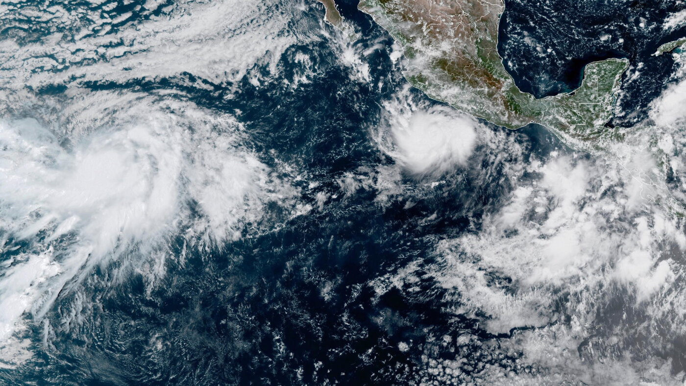
Hurricane Polo has rapidly intensified off the coast of Mexico to become one of the most powerful storms of the season in the Pacific Ocean.
asserted
Polo → publish → Ocean
A Hurricane Hunter aircraft, operated by the US National Oceanic and Atmospheric Administration (NOAA), flew into the storm on Tuesday and recorded sustained wind speeds near 180 mph (285 km/h), with stronger gusts.
NOAA's Miami-based National Hurricane Center called the storm "extremely dangerous" and said its intensification over 24 hours was "truly remarkable".
asserted
intensification → operate → hours
The slow-moving storm is fuelling up on extremely warm waters caused by the El Niño climate phenomenon and is the season's third category 5 storm, the highest level on the Saffir-Simpson scale.
asserted
storm → move → scale
The storm is predicted to skirt the coast of south-western Mexico, but is not expected to make landfall, a warning from NOAA said.
asserted
warning → predict → NOAA
As it slowly drifts northwest, Polo will drive torrential rainfall in parts of Mexico's south-west coast - which could lead to deadly flooding and mudslides, NOAA said.
uncertain
NOAA → drift → flooding
Rainfall totals of up to 6in (15cm) are forecast, with 8in possible in some areas.
asserted
in → forecast → areas
Residents have also been warned of large ocean swells and life-threatening surf conditions for the next few days.
asserted
Residents → warn → days
"So far, the information we have is that (Polo) will not make a direct landfall on the coast," Mexico's President Claudia Sheinbaum said on Tuesday, but she warned residents along the Pacific coast to be vigilant.
asserted
she → have → coast
Sheinbaum highlighted the states of Jalisco, Colima and Michoacan as being at risk.
asserted
Sheinbaum → highlight → risk
Data from the Hurricane Hunter aircraft indicated that Polo could still strengthen and would likely stay a category 5 storm for the next few days, because of what NOAA called a "very conducive" environment of extremely warm ocean waters feeding the storm.
uncertain
NOAA → indicate → storm
Scientists monitoring the ocean temperatures say the current El Niño climate phenomenon is now the strongest on record.
asserted
phenomenon → monitor → record
Daily sea surface temperatures in a key region of the central-eastern Pacific were 3.05C above average on 19 September - exceeding the previous record of 3.02C set during the very strong El Niño of 2015.
asserted
temperatures → exceed → 2015
Some longer-term measures of El Niño have not yet hit record levels but this is likely to change, with the peak not expected until later this year.
asserted
peak → hit → year
Warmer ocean waters mean storms can pick up more energy, leading to higher wind speeds.
asserted
storms → mean → speeds
El Niño is a naturally-occurring pattern, which happens about every two to seven years and tends to last for around a year.
asserted
which → occur → year
Trade winds that typically blow from east to west across the Pacific Ocean can weaken or even reverse, allowing warm water to spread eastwards.
asserted
water → blow → Ocean
Heat is then released from the ocean into the atmosphere which can boost global temperatures and drive changes in weather patterns around the world.
asserted
which → release → world
 The Aporia