North Carolina’s coastal forests on the Albemarle Peninsula are rapidly disappearing, with a study showing a 21.1% decline in forest cover between 1985 and 2021, equating to approximately 64,220 hectares lost. The rate of this transformation has accelerated since 2010, with the spread of ghost forests—areas where saltwater intrusion kills freshwater-dependent trees—increasing by about 7,561 hectares between 2010 and 2021, compared to 3,087 hectares from 1985 to 2010. The study attributes this change primarily to rising sea levels and increased soil salinity, exacerbated by extreme weather events like droughts and hurricanes.
Written locally by qwen2.5:14b on 2026-10-08,
using this article's own text rather than the other coverage of the
same event (that is the story summary below).
Story summary
North Carolina's coastal forests on the Albemarle Peninsula have been rapidly declining, with a new study published in PLOS One revealing that over one-fifth (21.1%) of forest cover disappeared between 1985 and 2021, losing approximately 64,220 hectares. The research, conducted by North Carolina State University, shows the pace of loss accelerated significantly after 2010, with about 23,876 hectares converted to marsh, shrubs, or ghost forests between 2010 and 2021, nearly doubling the rate observed from 1985 to 2010. This transformation is attributed to factors such as rising sea levels, increasing salinity, and proximity to coastal channels. The study highlights that 304,729 hectares of forest cover in 1985 shrunk to 269,970 hectares by 2021, underscoring the urgent need for conservation efforts as these changes have significant ecological and economic impacts.
Written for “Coastal Forest Loss Accelerating” on 2026-10-08,
grounded in this article and the 0 other(s) covering the same event.
North Carolina’s coastal forests are retreating at a faster pace, with a new study finding that more than one-fifth of forest cover across part of the state’s coastal plain disappeared between 1985 and 2021.
asserted
fifth → retreat → 1985
The findings, published in PLOS One and reported by North Carolina State University and Phys.org, show that forest loss accelerated significantly after 2010.
asserted
loss → publish → 2010
Researchers say rising sea levels, increasing salinity and the landscape’s proximity to coastal channels are driving much of the change.
asserted
levels → say → change
The study focused on the Albemarle Peninsula, a low-lying area that includes private land as well as protected areas such as Pocosin Lakes National Wildlife Refuge.
asserted
that → focus → Refuge
Researchers found that forest cover fell from about 304,729 hectares in 1985 to 269,970 hectares in 2021.
asserted
cover → find → 2021
That represents a net decline of 21.1%, or approximately 64,220 hectares.
asserted
That → represent → %
But the change was not evenly distributed over the 36-year period.
asserted
change → distribute → period
Between 2010 and 2021, about 23,876 hectares of forest were converted to marsh, shrubs or ghost forest.
asserted
hectares → convert → marsh
That was 1.5 times the 16,968 hectares that underwent the same transition between 1985 and 2010.
asserted
that → undergo → 1985
Rising seas are changing the landscape
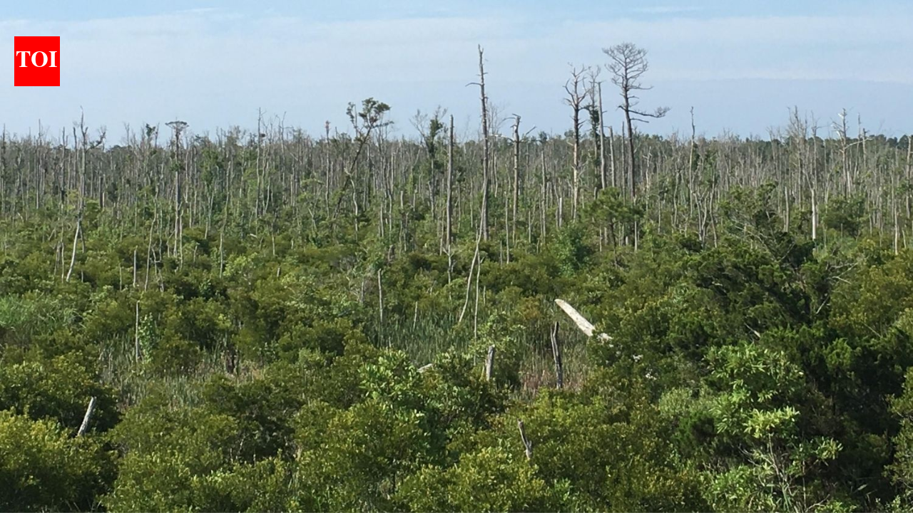
One of the clearest signs of the transformation is the spread of ghost forests.
asserted
One → rise → forests
These are areas where freshwater-dependent trees have died as saltwater moves inland, leaving behind stands of pale, dead trees surrounded by shrubs or marsh vegetation.
asserted
saltwater → die → shrubs
The researchers found that ghost forest area increased by about 7,561 hectares between 2010 and 2021, compared with 3,087 hectares during the earlier 1985-2010 period.
asserted
area → find → period
That means the rate of ghost forest expansion was roughly 2.5 times higher in the later period.
asserted
rate → mean → period
Rising seas can push saltwater farther inland and raise coastal water tables, exposing tree roots to conditions they cannot tolerate.
asserted
they → rise → conditions
Saturated soils can also become oxygen-poor, putting additional stress on trees.
asserted
soils → become → trees
North Carolina’s Forest Service has previously documented the same process, noting that saltwater intrusion and rising coastal groundwater can leave once-healthy forests filled with standing dead trees.
asserted
intrusion → document → trees
The agency says more than 61,000 acres of forestland affected by sea-level rise had been mapped in eastern North Carolina as of 2024.
asserted
acres → say → 2024
Earlier research has also shown how quickly the transition can occur.
asserted
transition → show → ?
A 2020 study archived by NOAA found that 15% of unmanaged public land examined in coastal North Carolina changed from forest to transitional ghost forest between 2001 and 2014, with salinity and proximity to estuarine shorelines among the significant drivers.
asserted
% → archive → drivers
Extreme weather can make the decline worse
Sea-level rise is not acting alone.
asserted
rise → make → ?
The researchers identified areas that experienced severe drought between 2007 and 2011 as well as Hurricane Irene in 2011 that failed to fully recover afterward.
asserted
that → identify → 2011
Such events can leave coastal forests more vulnerable to saltwater and prolonged flooding.
asserted
events → leave → saltwater
Once trees die, salt-tolerant shrubs and marsh vegetation can move into the area, pushing the landscape toward a different ecological state.
asserted
shrubs → die → state
The study also found that more than 30,000 hectares of the forest loss was converted to cultivated land, while other areas became shrubland, marsh, water or ghost forest.
asserted
areas → find → land
Of the 64,220 hectares of net forest loss, about 33,884 hectares transitioned into those natural coastal vegetation and water categories.
asserted
hectares → transition → categories
Satellites helped reveal the long-term change
To reconstruct decades of change, researchers combined satellite imagery with an artificial intelligence model designed to classify different types of land cover.
asserted
researchers → help → cover
They compared Landsat imagery with the newer, higher-resolution Sentinel-2 data. Sentinel-2 performed better when both systems were tested against the same 2021 landscape, but Landsat provided something the newer system could not: a much longer historical record.
That made Landsat essential for tracing how the coastal landscape changed from 1985 onward.
uncertain
landscape → compare → 1985
The researchers also found that combining seasonal and topographic information improved the ability of the model to distinguish ghost forests from other vegetation.
asserted
combining → find → vegetation
The researchers say the results can help identify coastal areas most vulnerable to continued forest retreat.
asserted
results → say → retreat
Earlier work in the region has similarly shown that ghost forests are an early warning sign of saltwater intrusion and rising seas, making their spread useful for tracking broader changes along the coast.
asserted
spread → show → coast
 The Aporia