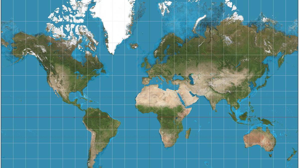
Photo via Al Jazeera

Japan, India, Ukraine: Why some countries are uneasy about new UN map

Read the original at Al Jazeera ↗
Cite

Al Jazeera Staff. (2026, September 11). Japan, India, Ukraine: Why some countries are uneasy about new UN map. Al Jazeera. https://www.aljazeera.com/news/2026/9/11/japan-india-ukraine-why-some-countries-are-uneasy-about-new-un-map?traffic_source=rss

Dated when The Aporia collected the article, usually within hours of publication. Check the original for its exact date and byline.

Al Jazeera · collected 2026-09-11 · by Al Jazeera Staff

Quick Summary

The United Nations General Assembly voted last week to encourage the use of new world maps that more accurately depict continents with their true sizes, with 164 countries in favor and six abstaining. The US was the only country to oppose the resolution, which promotes the Equal Earth projection over the widely used Mercator projection. India, Ukraine, and Japan have expressed concerns about how disputed territories should be depicted on the new maps. According to experts, the Mercator projection disproportionately shrinks Africa's size, while making Europe and the US appear larger than they are in reality.
Written by AI on 2026-09-11, from this article's own text only (the story summary below draws on all the coverage).
See how they differ ↓

AI analysis

Story summary

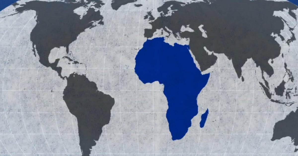
September 4th, 164 countries, including France and the UK, voted in favor of a resolution at the UN General Assembly to adopt a new world map that more accurately reflects the size of Africa. Only the US voted against it, with six other states abstaining. The new map, known as the Equal Earth cartographic projection, aims to provide a more accurate representation of continental landmasses and reduce distortions caused by the traditional Mercator projection, which has been widely used since the 16th century. According to Foreign Minister Robert Dussey of Togo, "a fair world begins with a fair map," highlighting the importance of cartography in shaping our understanding of the world. The resolution promotes the use of the Equal Earth projection over the Mercator projection, which distorts the relative size of land masses by expanding those nearer the poles, making Greenland appear roughly the same size as Africa, although Africa is about 14 times larger.

Written for “UN Adopts New World Map” on 2026-11-20, grounded in this article and the 24 other(s) covering the same event.

How they differ

15 outlets covered “UN Adopts New World Map”.

What each outlet says

One AI summary per outlet of its latest article on this story, written from that article alone and checked against it. Open the article for the outlet's own words.

Al JazeeraThis outlet11 Sep

The United Nations General Assembly voted last week to encourage the use of new world maps that more accurately depict continents with their true sizes, with 164 countries in favor and six abstaining. The US was the only country to oppose the resolution, which promotes the Equal Earth projection over the widely used Mercator projection. India, Ukraine, and Japan have expressed concerns about how disputed territories…

Japan, India, Ukraine: Why some countries are uneasy about new UN map (this article)3 articles from Al Jazeera on this story
The Hindu6 Sep

The United Nations has approved a resolution in support of an alternative map that accurately represents Africa's size, which is often distorted on traditional Mercator projections. The resolution promotes the Equal Earth projection as a more accurate representation. The U.N.'s backing aims to correct centuries-old cartographic inaccuracies. No specific numbers or details about the resolution are provided.

U.N. approves resolution in support of map that shows Africa’s true size →4 articles from The Hindu on this story
The Straits Times4 Sep

The United Nations General Assembly voted to adopt a new world map, known as the Equal Earth cartographic projection, which makes Africa larger while shrinking North America and Europe, with 164 countries in favor and the US voting against it. The resolution aims for a more accurate representation of world geography. Six other states abstained from the vote. The new map is intended to replace the traditional…

While You Were Sleeping: 5 stories you might have missed, Sept 5, 2026 →3 articles from The Straits Times on this story
The Guardian11 Sep

Japan has asked the operator of a new UN world map, known as the Equal Earth cartographic projection, to revise the map because it incorrectly shows the Kuril islands belonging to Russia. The disputed islands are also known in Japan as the Northern Territories and have been at the center of a long-standing territorial dispute between Japan and Russia. 164 UN members voted to adopt the new map on Friday, but it has…

Japan seeks change to new UN world map over Russia 'misconception' →2 articles from The Guardian on this story
BBC5 Sep

The United Nations has adopted a new map called the Equal Earth projection to replace the widely used Mercator map, which distorts the size of continents such as Africa. The Mercator map was created in 1569 by Flemish cartographer Gerardus Mercator for navigation purposes and still influences many modern maps, including Google Maps. The key issue with the Mercator map is that it makes countries near the equator…

What different world maps get right - and what they get wrong →2 articles from BBC on this story
CBS News6 Sep

The United Nations General Assembly on Friday endorsed a new world map called the Equal Earth projection, which accurately represents Africa's larger size compared to Greenland. The resolution, sponsored by Togo and backed by African countries, was passed with 164 votes in favor, including opposition from only the US, and six abstentions. The new map shows continents in their true proportions, with Africa being 14…

UN endorses new map that shows Africa's size more accurately →2 articles from CBS News on this story
Show 9 more outlets
South China Morning Post4 Sep

The UN General Assembly voted 164-1 on Friday, with six abstentions, to adopt a new map called the Equal Earth cartographic projection. The resolution, spearheaded by African countries, makes Africa appear larger while shrinking North America and Europe compared to the traditional Mercator map. This shift is aimed at achieving "a more accurate representation" of continental landmasses, according to the resolution…

UN adopts new map: Africa bigger, North America and Europe smaller →
Dawn4 Sep

The UN General Assembly voted 164-0 (with 6 abstentions) to adopt a new map that makes Africa appear larger and shrinks North America and Europe. The resolution, led by several African countries, aims for a "more accurate representation" of world geography using the Equal Earth cartographic projection. According to cartographers, this new map preserves the relative surface areas of continents and shows their shapes…

UN adopts major map reform to show true scale of continents →
ABC News (AU)4 Sep

The United Nations General Assembly has voted to adopt a new world map, known as the Equal Earth cartographic projection, which makes Africa appear larger and North America smaller compared to the traditional Mercator projection. The motion was carried by 164 countries, with six abstaining and the US voting against it. The resolution aims to provide a more accurate representation of continental landmasses, with the…

Africa bigger, US smaller as UN votes to adopt a new world map →
NPR4 Sep

The United Nations General Assembly has overwhelmingly backed a resolution, known as "Correct the Map", to change how Africa is represented on world maps. The vote was 164 to one, with six countries abstaining, and the only country voting against it was the United States. The resolution encourages the use of equal-area projections, such as Equal Earth, which more accurately show the true relative size of countries…

The U.N. backs a new world map showing Africa in its true relative size →
National Post5 Sep

The UN General Assembly voted 164-0 (with six abstentions) on Friday to adopt a new world map called the Equal Earth cartographic projection, which makes Africa larger and North America and Europe smaller. The resolution aims to provide a more accurate representation of continental landmasses, replacing the traditional Mercator projection that was designed in 1569 for maritime navigation. France co-sponsored the…

UN adopts ‘more accurate’ world map with larger Africa and smaller North America, Europe →
Times of India5 Sep

The United Nations General Assembly has endorsed a new world map called the Equal Earth projection, which accurately reflects Africa's size. 164 countries voted in favor of the resolution, while the US was opposed and six countries abstained. The new map shows Africa as about 14 times larger than Greenland, whereas under the traditional Mercator projection, they appear roughly comparable in size. The resolution…

A bigger Africa & a smaller Europe: What changes in new UN-backed world map →
Sydney Morning Herald5 Sep

The United Nations has voted to adopt a new world map that more accurately reflects countries' true size, shifting away from the 16th-century Mercator map. The resolution, sponsored by African states, passed with 164 votes in favor and 1 against, with some critics arguing that the Mercator map creates a subtle bias towards northern nations. Africa is about 14 times larger than Greenland, which appears roughly the…

Australia and Africa expand, North America and Europe shrink: UN adopts new world map →
Daily Mail6 Sep

The United Nations General Assembly has voted to adopt a new world map, known as the Equal Earth projection, which makes Africa appear larger and corrects what critics call "cartographic colonialism". The resolution, sponsored by Togo and backed by 164 member states, aims to move away from the centuries-old Mercator map. A key aspect of the change is that Africa will appear about 14 times larger than it does on the…

United Nations adopt new world map that shows Africa much bigger and cuts size of UK and US →
The Independent6 Sep

The UN General Assembly has voted in favor of a resolution sponsored by Togo to replace traditional world maps with more accurate representations of nations' sizes. The "Correct the Map" resolution passed with 164 votes in support and was opposed by only the US, with six other countries abstaining. The resolution encourages governments, schools, and companies to use maps that accurately depict Africa's size, which…

UN votes to approve new world map which will show true size of Africa →

Where they agree and split

Agreed

Reported by outlets on both sides of the middle

“Maps shape our understanding of the world,” Togo’s foreign minister Robert Dussey was quoted by the UN as saying ahead of the vote.

9 outlets
Show 3 more

The "Correct the Map" resolution, sponsored by Togo and backed by African Union (AU) members, passed with the support of 164 nations, including France and the UK.

6 outlets

France – which co-sponsored the resolution in support of the new map – announced on Sept 4 that it would abandon the Mercator projection.

5 outlets

“They are therefore never neutral, when they present a distorted image of our planet, they risk perpetuating inaccurate representation that are passed down through generation.”

4 outlets

Disputed

Picked by our model, which is sometimes wrong

  • The US representative criticized the resolution as a reason for the UN losing credibility, whereas other countries supported it.45

Framing

How the first headlines put it

  • South China Morning Post and The Straits Times emphasize that Africa is shown larger while North America and Europe are smaller in the new map.13
Stated as fact12
The headlines (12)

UN votes to adopt new world map that shows Africa’s true scale The Guardian · stated as fact

UN adopts new map: Africa bigger, North America and Europe smaller South China Morning Post · stated as fact

UN adopts new world map showing true scale of continents; only US votes against it The Straits Times · stated as fact

U.N. approves resolution in support of map that shows Africa’s true size The Hindu · stated as fact

UN adopts major map reform to show true scale of continents Dawn · stated as fact

UN votes to adopt new world map to reflect Africa's true size BBC · stated as fact

Africa bigger, US smaller as UN votes to adopt a new world map ABC News (Australia) · stated as fact

The U.N. backs a new world map showing Africa in its true relative size NPR · stated as fact

UN votes to adopt new world map that reflects Africa’s true size Al Jazeera · stated as fact

UN adopts ‘more accurate’ world map with larger Africa and smaller North America, Europe National Post · stated as fact

A bigger Africa & a smaller Europe: What changes in new UN-backed world map Times of India · stated as fact

Australia and Africa expand, North America and Europe shrink: UN adopts new world map Sydney Morning Herald · stated as fact

The full story: what happened, how it changed, and all 25 articles →

Compared with similar articles

This article reads unscored and hedges 6% of its claims. Each row says how that neighbour differs.
CBS News
Hedges 0 of 3 claims Outlet record 67/100
CBS News
Hedges 0 of 15 claims Outlet record 67/100
Daily Mail
Hedges 1 of 23 claims Outlet record 69/100
The Hindu
Leans left Hedges 0 of 8 claims Outlet record 60/100
The Hindu
Hedges 0 of 2 claims Outlet record 60/100
The Independent
Hedges 2 of 25 claims Outlet record 59/100
The Guardian
Hedges 0 of 11 claims Outlet record 64/100
Al Jazeera
Leans left Hedges 0 of 21 claims Outlet record 60/100
“Article A discusses the Mercator projection's distortion, while Article B reports on a UN General Assembly vote to encourage new maps with accurate continent sizes”
The Hindu
Leans left Hedges 1 of 6 claims Outlet record 60/100
“Article A discusses the African Union's endorsement of a map change, while Article B reports on the UN General Assembly's vote to encourage new maps, which happened later”

Story

UN Adopts New World Map
World · 25 article(s) covering the same event. Compare every outlet's account →
How this article was measured signals, leaning charts, publisher record, byline, topics and claims

Signals How these are calculated →

Claims extracted
51
sentences that state something as happening or true
Uncertain
6%
3 of 51 hedged ("reportedly", "may", "according to")
Leaning
withheld
no quote in the article backed the model's score
Publisher signals
60/100
Al Jazeera's corrections and hedging, across everything collected from it. Not a measure of accuracy.
Outlets on this story
25
World
Same framing elsewhere
1
articles that frame the event the way this one does
Analyzed 2026-09-11 · how these are computed

How this is being covered How these are calculated →

Article leaning vs. publisher reliability
Source leaning vs. consistency

Publisher

Al Jazeera · 6131 article(s) · 4 correction(s) detected
Running correction rate · 4 correction(s)

Who wrote this

Al Jazeera Staff
1170 article(s) here · 1 carrying a prediction
Kyiv Mayor Vitali Klitschko said ballistic missiles had damaged the Podilskyi, Darnitskyi, and Southern bridges, requiring traffic restrictions across the Dnipro.
2026-11-20 · assertive framing · Russia unleashes retaliatory barrage on Kyiv bridges
The populist is widely expected to win the race thanks to the huge political support earned by his crackdown on El Salvador’s violent cartels.
British and European Union leaders are set to meet at a summit billed as a chance to reset relations a decade after the Brexit vote.
The journey would usually take about two and a half hours, but as he accelerated along the road, Yazan noticed that the car was struggling to pick up speed.
“When we set our net zero emissions goal, we anticipated steady growth, falling clean energy costs, and changes in the broader system that would enable progress at the pace we envisioned.
That will give the party power over Congress’s ability to oversee investigations and issue subpoenas.
Salvadoran President Nayib Bukele is set to formally register his candidacy for his country’s upcoming presidential race, as he seeks a third consecutive term.
Four bodies have been recovered after a migrant boat capsized off Senegal’s coast, as authorities continue searching for survivors amid fears that the death toll could rise significantly.
Iraqi Prime Minister Ali al-Zaidi says his country’s security forces will establish a joint operations centre in the town of Jurf al-Sakhar, in a compromise with the Iranian-backed Kataib Hezbollah armed group over control of a strategic area south of Baghdad.
He said further measures would be announced in the coming days to ensure those responsible are held accountable.
Wire or desk byline, not an individual reporter.
Also by Al Jazeera Staff
Nothing else under this byline is closely related to this article, so these are simply their most recent.
All 1170 articles by Al Jazeera Staff →

Topics

4UN African Mercator the African Union the United Nations General Assembly

Subjects

Ukraine GPE · 7× African NORP · 3× Russian NORP · 3× Kyiv ORG · 2× Russia GPE · 2× 4UN ORG · 1× The United States GPE · 1× Ukrainian NORP · 1× the African Union ORG · 1× the United Nations General Assembly ORG · 1×

Narrative

“It would be a truly fatal mistake for all of us, and for this General Assembly, to seek to correct a historical injustice in the geographical depiction of countries and continents by simultaneously allowing a deeply troubling interpretation of the text of this draft resolution,” he added.
framing: assertive · carried by 1 article(s) · first seen 2026-09-11
For example, Greenland is shown as roughly the same size as Africa, but, in reality, it could fit into the continent 14 times over.
2026-09-11 · Al Jazeera
Japan, India, Ukraine: Why some countries are uneasy about new UN map · assertive framing

Claims (51 extracted, 3 hedged)

In a historic move last week, the United Nations General Assembly voted overwhelmingly to encourage the use of new world maps which more accurately depict continents with their true sizes. asserted
which → vote → sizes
The move followed months of lobbying by the African Union, which itself adopted a new map earlier in February. asserted
which → follow → February
A total of 164 countries voted in favour while six abstained. asserted
six → vote → favour
you guess the real size of each country on the new world map? asserted
you → guess → map
- list 3 of 4The Map Was Lying To You: Why the UN Just Changed How We See Africa - list 4 of 4In maps and charts: Russian and Ukrainian attacks on civilian targets The United States was the only member to oppose it. asserted
States → lie → it
US representative Yaryna Ferencevych said before the vote that the resolution was “the reason this institution is losing its credibility”. asserted
institution → say → credibility
“Instead of focusing on genuine problems … this body is debating map projects from the 16th century,” she said. asserted
she → focus → century
But since the resolution was approved, at least three other countries have voiced concerns about the changes: India, Ukraine and Japan. asserted
countries → approve → changes
None are explicitly opposed to adopting a new projection. asserted
None → oppose → projection
However, they are raising concerns about how certain disputed territories should be depicted. asserted
territories → raise → concerns
Here’s what we know: asserted
we → ’ → what
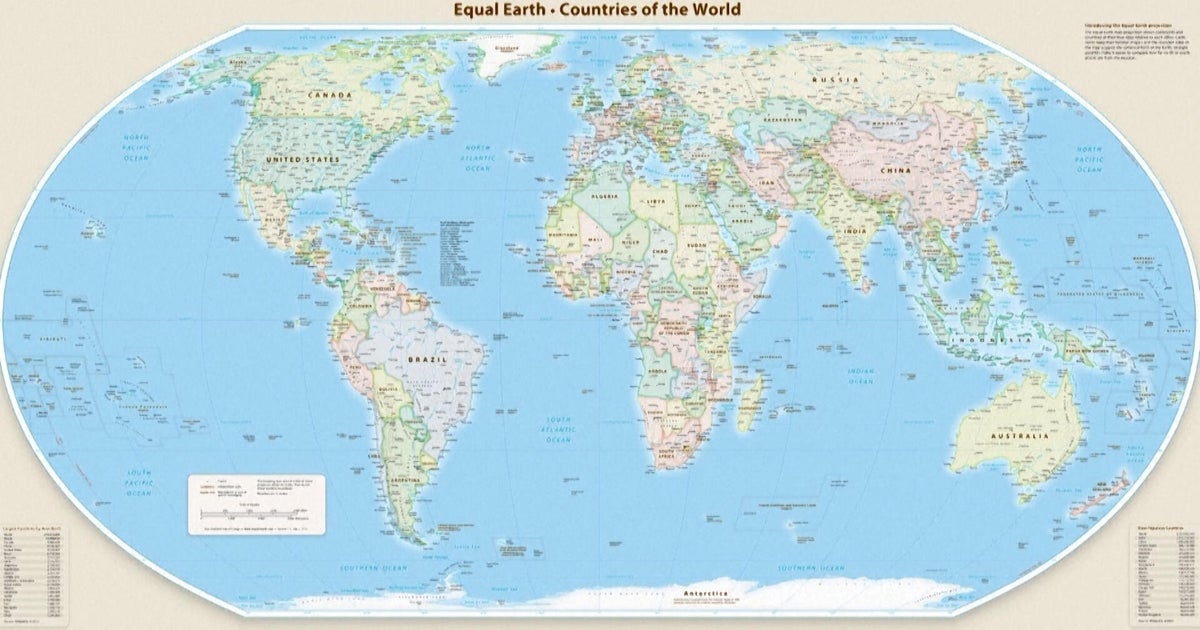
The UN endorsed a resolution promoting the Equal Earth projection of the world map, rather than the Mercator projection, which is currently widely used. asserted
which → endorse → map
The resolution does not ban Mercator or impose a particular replacement – it merely encourages nations to adopt the Equal Earth version, which was created by three researchers in 2018. asserted
which → ban → 2018
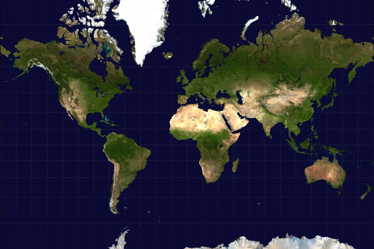
The Mercator projection, which was produced by Flemish cartographer Gerardus Mercator in 1569 when the West was busy “conquering” new territories, attempts to show a three-dimensional globe on a two-dimensional surface. asserted
West → produce → surface
That is why countries closer to the poles appear much larger than countries at the equator. asserted
countries → appear → equator
For decades, map experts have pointed out that Mercator’s projection disproportionately shrinks the true size of the African continent and that of other developing regions, while making Europe and the US seem much larger by comparison. asserted
Europe → point → comparison
For example, Greenland is shown as roughly the same size as Africa, but, in reality, it could fit into the continent 14 times over. uncertain
it → show → continent
Europe, which is portrayed as bigger than South America, is actually half its size. asserted
which → portray → America
Advocates from African countries pointed out that the map is problematic because of the size issues. asserted
map → point → issues
Importantly, they argued, it reinforces negative perceptions of Africa. asserted
it → argue → Africa
Several cartographers have attempted to develop equal area maps. asserted
cartographers → attempt → maps
However, African activists specifically pushed for the Equal Earth projection map, which significantly expands Africa and shrinks Europe and the US. asserted
which → push → Europe
Experts say while maps are inherently inaccurate because of the constraints of depicting a spherical world on a flat plane, the Equal Earth projection is as close as it gets. asserted
it → say → plane
Why is Ukraine worried about the new map? asserted
Ukraine → worry → map
Ukraine was one of six countries which abstained from the vote at the UNGA, along with Estonia, Georgia, Moldova, Serbia and Lithuania, who voted in solidarity with Ukraine. asserted
who → abstain → Ukraine
Kyiv has complained that the Equal Earth projection depicts the Russian-occupied Crimean peninsula in a distinctly lighter shade than mainland Ukraine. asserted
projection → complain → Ukraine
Russia illegally occupied and annexed Crimea in February 2014, a move the UN has denounced. asserted
UN → occupy → February
Although the peninsula is also shaded differently from mainland Russia on the new map, its yellowish tint appears closer to the Russian shade than Ukraine’s. asserted
tint → shade → Ukraine
“Ukraine does not in principle oppose the core issue addressed in this draft resolution,” Andrii Melnyk, the country’s permanent representative to the UN, said in an address to the assembly. asserted
Melnyk → oppose → assembly
Melnyk said Kyiv had asked for corrections before the vote but had not received positive responses. asserted
Kyiv → say → responses
The new map, he said, could be tantamount to opening a Pandora’s box, enabling the “abuse and distortion” of the world map. uncertain
he → say → map
“It would be a truly fatal mistake for all of us, and for this General Assembly, to seek to correct a historical injustice in the geographical depiction of countries and continents by simultaneously allowing a deeply troubling interpretation of the text of this draft resolution,” he added. asserted
he → seek → resolution
What is Japan demanding? asserted
Japan → demand → What
Meanwhile, on Thursday, Tokyo, which voted in favour of the new map, said it had also asked for corrections to the Equal Earth projection because the map uses the same colours and shades for Russian territory as it does for the disputed Kuril Islands. asserted
it → vote → Islands
Russia and Japan have long fought over control of the four islands, known in Russia as the Southern Kurils and in Japan as the Northern Territories. asserted
Russia → fight → Territories
In 1945, during World War II, the Soviet Union invaded and annexed the islands as part of a pact with Western Allies that stipulated the Soviets would take the disputed territory. asserted
Soviets → invade → territory
The islands’ Japanese inhabitants were removed. asserted
inhabitants → remove → ?
Subsequently, Japan and the US have claimed that the islands were not part of the original pact. asserted
islands → claim → pact
The islands, however, remain under Russian administration. asserted
islands → remain → administration
In August this year, Russia’s President Vladimir Putin paid his first-ever visit to the islands, drawing condemnation from Japan. asserted
Putin → pay → Japan
…and 11 more, not listed.
Give feedback · no sign-in needed

No sign-in needed for now. Your note is sent without a name, so it cannot be answered.

History Support