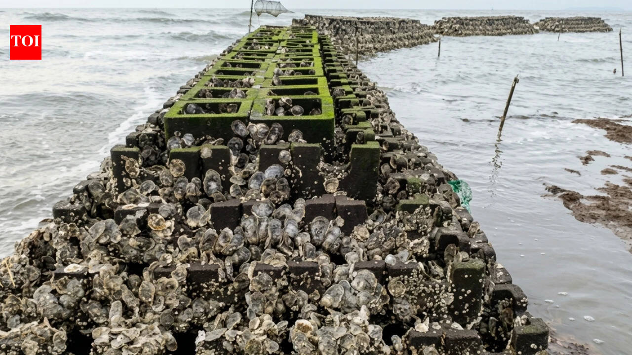
In an unusual effort to protect an eroding stretch of New Jersey’s Delaware Bay shoreline, 40 constructed oyster reefs were installed at Gandy’s Beach Preserve between 2015 and 2016.
asserted
reefs → protect → 2015
A new study published in Frontiers in Marine Science examined the project along with other nature-based coastal protection measures used in New Jersey.
asserted
study → publish → Jersey
Researchers found that while such projects can help restore habitats, their ability to protect coastlines often requires continued maintenance.
asserted
ability → find → maintenance
The manmade reefs at Gandy’s Beach quickly attracted oysters.
asserted
reefs → attract → oysters
In 2016 and 2017, researchers recorded average densities of more than 800 live oysters per square metre.
asserted
researchers → record → metre
The reefs also reduced waves during storms when they were above water or only slightly submerged.
asserted
they → reduce → water
During four nor’easters in 2018, wave height fell by 41% across the reefs and by as much as 51% between the seaward and most landward monitoring points.
asserted
height → fall → points
However, the protection weakened when the reefs were fully underwater.
asserted
reefs → weaken → ?
Over seven years, the reef groups also lost about 20 centimetres of elevation on average, while the site recorded a net loss of 558 square metres of vegetation.
asserted
site → lose → vegetation
Protecting Gandy’s Beach
Gandy’s Beach Preserve in Cumberland County had been losing shoreline for decades.
asserted
Preserve → protect → decades
Around 152 metres of shoreline disappeared between 1930 and 2007, an average retreat of about 0.61 metres a year.
asserted
metres → disappear → metres
In some areas, erosion reached about 3.6 metres a year.
asserted
erosion → reach → metres
Hurricane Sandy in 2012 worsened the erosion.
asserted
Sandy → worsen → erosion
The oyster reef project was later developed to test whether a living shoreline could protect the coast under the relatively strong wave conditions of Delaware Bay.
uncertain
shoreline → develop → Bay
The project included 27 “oyster castle” breakwaters made from interlocking concrete blocks and 13 reefs made from bags filled with oyster, clam and whelk shells.
asserted
project → include → shells
Together, the reefs covered about 25% of the targeted 800-metre shoreline.
asserted
reefs → cover → shoreline
Gaps were left between them to allow horseshoe crabs to reach spawning areas.
asserted
crabs → leave → areas
Reefs cut storm waves
Researchers monitored the reefs for seven years, studying waves, erosion, vegetation, oysters, fish habitat and the condition of the structures.
asserted
Researchers → cut → structures
During four nor’easters in winter 2018, the reefs worked best when their crests were exposed or only slightly underwater.
asserted
crests → work → winter
Significant wave height fell by 41% across the reefs and by up to 51% between the seaward and landward monitoring points.
asserted
height → fall → points
Average vertical erosion in the protected area was 0.25 centimetres, compared with 1.52 centimetres at a control site.
But the reefs were submerged for more than 85% of the tidal cycle.
asserted
reefs → protect → cycle
fully underwater, their ability to reduce waves dropped sharply.
asserted
ability → reduce → waves
Monitoring in 2019 even recorded some cases in which waves became larger behind the submerged reefs.
asserted
waves → record → reefs
Oysters quickly colonised reefs
asserted
Oysters → colonise → reefs
The reefs performed better as habitats.
asserted
reefs → perform → habitats
Oysters rapidly colonised the structures, with average densities exceeding 800 live oysters per square metre in 2016 and 2017.
asserted
densities → colonise → 2016
A major oyster mortality event occurred in the winter of 2018-2019, likely because of extreme changes in water temperature.
asserted
event → occur → temperature
The population later recovered.
asserted
population → recover → ?
By 2021-2022, researchers recorded 84 to 157 oysters per square metre on oyster castles and 189 to 462 per square metre on shell bags.
asserted
researchers → record → bags
Ribbed mussels also colonised the reefs.
asserted
mussels → colonise → reefs
Surveys between 2015 and 2021 recorded 45 fish and invertebrate taxa and more than 12,000 individuals.
asserted
Surveys → record → taxa
However, these ecological gains did not stop the broader physical changes at the site.
asserted
gains → stop → site
By 2022, all reef groups had lost about 20 centimetres of elevation on average.
asserted
groups → lose → elevation
Some shell bags had also been moved or scattered by strong waves, while vegetation declined by a net 558 square metres between 2016 and 2022.
asserted
vegetation → move → 2016
Why protection remained limited
The study found that the reefs were not large enough to deal with the conditions at Gandy’s Beach.
asserted
reefs → remain → Beach
Early planning had underestimated shoreline erosion and incoming waves, while Hurricane Sandy had also changed the nearshore area.
asserted
Sandy → underestimate → area
Regulations required the reef crests to remain below the mean high-water level.
asserted
Regulations → require → level
As a result, they spent most of the tidal cycle submerged, when their ability to reduce waves was weakest.
asserted
ability → spend → waves
Rising sea levels add to the problem.
asserted
levels → rise → problem
Relative sea level at Gandy’s Beach is increasing by about five to six millimetres a year, meaning fixed-height reefs are likely to spend more time underwater.
asserted
reefs → increase → time
…and 2 more, not listed.
 The Aporia