What different world maps get right - and what they get wrong

BBC News · collected 2026-09-05 · by Jaroslav Lukiv
Read the original at BBC News ↗

Summary

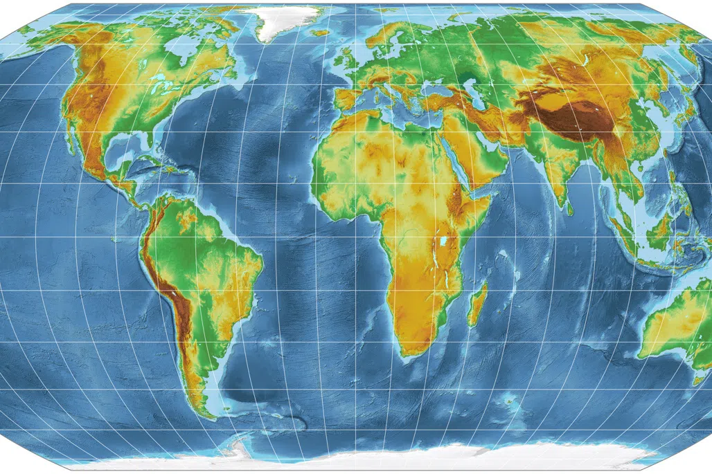
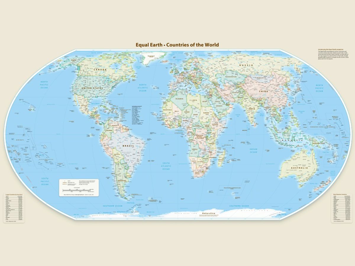
The United Nations has adopted a new map called the Equal Earth projection to replace the widely used Mercator map, which distorts the size of continents such as Africa. The Mercator map was created in 1569 by Flemish cartographer Gerardus Mercator for navigation purposes and still influences many modern maps, including Google Maps. The key issue with the Mercator map is that it makes countries near the equator appear smaller than they are and those near the poles appear larger, downplaying Africa's importance. The new Equal Earth map was developed in 2018 to accurately represent landmass sizes but sacrifices straight lines, making it unsuitable for navigation and measuring distances.
Written by the local model on 2026-09-06, using this article's own text rather than the other coverage of the same event.

Signals How these are calculated →

Claims extracted
34
claim-shaped sentences
Uncertain
3%
1 of 34 hedged
Leaning
Leans left
of the writing, not the subject
Publisher trust
95.5
red-flag proxy, not a credibility rating
Outlets on this story
unclustered
not grouped into a story yet
Narrative spread
1
articles carrying this framing
Analyzed 2026-09-06 · source text last changed 2026-09-06 · how these are computed

AI analysis (generated at analysis time, not now)

Why this leaning score
The article's own words the score was based on. Each is quoted verbatim and was checked against the article text before being stored, so you can find it in the original.
Score -0.35 Confidence medium
Leaning score -0.35 for article 4983 (medium confidence, 1 verified quote) · logged 2026-09-06

How this is being covered How these are calculated →

Article leaning vs. publisher reliability
Source leaning vs. consistency

Compared with similar articles

This article reads leans left and hedges 3% of its claims. Each row says how that neighbour differs.
World news | The Guardian
⚖️ leaning not scored 🔴 3% hedged 1 of 31 📰 publisher trust 93
“Both articles report on the UN's adoption of a resolution to phase out the Mercator map and replace it with the Equal Earth design, at the same time (September 2026)”
News - South China Morning Post
⚖️ Leans left 🔴 0% hedged 0 of 6 📰 publisher trust 94
“Both articles report on the UN adopting a new map, specifically the Equal Earth cartographic projection, and describe its effects on the size of continents.”
The Straits Times World News
⚖️ Leans left 🔴 0% hedged 0 of 19 📰 publisher trust 95
“Both articles report on the UN General Assembly's adoption of a new world map, the Equal Earth projection, which accurately represents the size of continents, and mention that only the US voted against it.”
World News Today: International News Headlines - The Hindu | The Hindu
⚖️ leaning not scored 🔴 0% hedged 0 of 17 📰 publisher trust 95
“Both articles report on the UN's approval of a resolution to replace the Mercator map with one that accurately reflects countries' true size, specifically mentioning Africa's correct size and the 'Correct the Map' initiative.”
Dawn - Home
⚖️ leaning not scored 🔴 0% hedged 0 of 17 📰 publisher trust 95
“Both articles report on the UN adopting a resolution to replace the current map with the Equal Earth projection, which accurately represents the size of continents, and mention the same date.”
BBC News
⚖️ leaning not scored 🔴 4% hedged 1 of 26 📰 publisher trust 96
“Both articles report on the same UN General Assembly vote to adopt a new map that accurately reflects Africa's size, with identical resolution name and voting details.”
Just In
⚖️ Leans left 🔴 0% hedged 0 of 21 📰 publisher trust 96
“Both articles report on the UN voting to adopt a new map, specifically the Equal Earth cartographic projection, which accurately represents Africa's size and replaces the Mercator projection”
The Straits Times World News
⚖️ leaning not scored 🔴 0% hedged 0 of 18 📰 publisher trust 95
“Both articles report on the UN's approval of a resolution to replace the Mercator map with a new one that accurately reflects the size of Africa, which happened on the same date”
NPR Topics: News
⚖️ leaning not scored 🔴 3% hedged 1 of 29 📰 publisher trust 58
“Article A reports on the vote adopting the 'Correct the Map' resolution, while Article B mentions it as a past action and focuses on the implications of the new map”
Al Jazeera – Breaking News, World News and Video from Al Jazeera
⚖️ Leans left 🔴 0% hedged 0 of 26 📰 publisher trust 96
“Both articles report on the UN's adoption of a new map that accurately reflects Africa's size, citing the 'Correct the Map' resolution and referencing the previous Mercator map inaccuracies.”

Publisher

BBC News · 657 article(s) · 0 correction(s) detected
SignalValueWeight
Correction rate 0.000 0.4
Uncertainty density 0.091 0.25
Assertive mismatch rate 0.000 0.35
No corrections detected for this publisher. That may mean careful reporting, or simply that nothing has been checked.

Who wrote this

Jaroslav Lukiv
7 article(s) here · 1 carrying a prediction
🔮 While these alternate maps offer a different perspective on the world to the one we may be familiar with, they don't solve the issue of prominence, but rather simply change the focus of a map.
🔮 He added Russia would explain "how we see the situation".
2026-09-05 · assertive framing · US envoys meet Putin in Moscow for Ukraine talks
🔮 - Published US negotiators Steve Witkoff and Jared Kushner will visit Russia and Ukraine this weekend, as efforts to end the war appear to be gathering pace.
🔮 Friday's ruling by the Constitutional Council overrides the ban, which Emmanuel Macron had pledged would be introduced in stages from September.
🔮 The Cernavodă plant, where two reactors produce about 20% of Romania's electricity, is not expected to be restarted within the next 10 days.
🔮 The engine had undergone ultrasonic inspections in May this year with no findings of fault, the report stated.
🔮 It was feared the team would face repercussions for refusing to sing the Iranian anthem at their opening match, just days after the US-Israeli war against Iran began.
Also by Jaroslav Lukiv
Nothing else under this byline is closely related to this article, so these are simply their most recent.
All 7 articles by Jaroslav Lukiv →

Topics

African BBC Flemish Mercator the General Assembly

Subjects

Mercator ORG · 3× Peters PERSON · 3× BBC ORG · 2× African NORP · 1× European NORP · 1× Flemish NORP · 1× Gerardus Mercator PERSON · 1× James Cheshire PERSON · 1× University College London ORG · 1× the General Assembly ORG · 1×

Narrative

"You can preserve area, or you can preserve shape, or you can preserve distance and direction, but not everything at once perfectly, because otherwise you'd be back to a sphere," Cheshire said. Peters map The Peters world map was designed by German historian Arno Peters in the early 1970s.
framing: assertive · carried by 1 article(s) · first seen 2026-09-06
🔮 While these alternate maps offer a different perspective on the world to the one we may be familiar with, they don't solve the issue of prominence, but rather simply change the focus of a map.
2026-09-06 · BBC News
What different world maps get right - and what they get wrong · assertive framing

Claims (34 extracted, 1 hedged)

- Published The UN has just called for the predominant world map to be replaced with one that more accurately reflects the true size of continents such as Africa. asserted
that → publish → Africa
The "Correct the Map" resolution adopted by the General Assembly aims to fix the discrepancy with the Mercator map, in which the African continent is shown as being of similar size to Greenland - even though it is in reality about 14 times larger. asserted
it → correct → reality
The UN adopted a new map, the Equal Earth projection, which better represents the true sizes of landmasses - but comes with problems of its own. asserted
which → adopt → own
The now widely used Mercator map was created in 1569 by Flemish cartographer Gerardus Mercator. asserted
map → use → Mercator
Its main purpose was to help European sailors navigate the oceans, as cartography Professor James Cheshire at University College London explained. asserted
Cheshire → help → London
"He wanted a straight line to be drawn on a map to look like a straight line in reality if you followed a compass bearing," he told the BBC. asserted
he → want → BBC
"That was what it was intended to do, and that's what it does brilliantly well. asserted
it → intend → what
" To keep those angles correct on a flat map, Mercator had to stretch the grid lines wider as they moved away from the equator toward the poles. asserted
they → keep → poles
His map accommodates for the curvature of the Earth by making countries near the equator seem much smaller than they are and countries nearer the poles appear stretched. asserted
countries → accommodate → poles
The distortion is a result of it being impossible to accurately represent the surface of a globe on a two-dimensional chart. asserted
it → represent → chart
More than 450 years on, Mercator's creation is still the basis for many of the maps we see in classrooms, on TV and online, including Google Maps. asserted
we → see → Maps
But critics of the Mercator map say there is a psychological effect to viewing some places as smaller than they actually are and others as larger, as we instinctively view bigger things as more important. asserted
we → say → things
For Kenyan geographer Kioko Muendo, this has implicitly downplayed Africa's vast resources, population and investment opportunities. asserted
this → downplay → resources
"Maps are more than just guides for travellers - they shape how regions are perceived politically and economically," he told the BBC. asserted
he → shape → travellers
The Equal Earth map aims to address this problem with the Mercator projection. asserted
map → aim → projection
It was developed by a team of cartographers in 2018 to present the size and shape of landmasses more accurately, and was inspired by the 1963 Robinson projection - a map that shows the entire globe's surface at once. asserted
that → develop → surface
As a result, the Equal Earth map was adopted by African Union members in February, before it was adopted by the UN. asserted
it → adopt → UN
But it sacrifices the straight lines that made the Mercator projection perfect for navigating with - and it cannot be used for measuring the true distance between different places. asserted
it → sacrifice → places
"You can preserve area, or you can preserve shape, or you can preserve distance and direction, but not everything at once perfectly, because otherwise you'd be back to a sphere," Cheshire said. Peters map The Peters world map was designed by German historian Arno Peters in the early 1970s. asserted
map → preserve → 1970s
The rectangular map is based on the projection first described by Scottish cartographer James Gall in 1855. asserted
map → base → 1855
The projection sacrifices accuracy of shape in favour of accuracy of scale. asserted
projection → sacrifice → scale
So, polar regions are squished, while the bits near the equator are stretched. asserted
bits → squish → equator
This fixes the Greenland-Africa size issue, allowing those who use it to get a sense of the comparative size of different landmasses, all while preserving straight lines of longitude and latitude. asserted
who → fix → longitude
However, the map severely distorts the shapes of Earth's landmasses, making them all look slightly off. asserted
them → distort → landmasses
Russia, for instance, looks much smaller than it actually is. asserted
it → look → instance
The straight lines on the Peters map also do not represent true constant compass bearings and so are useless for navigation. asserted
lines → represent → navigation
In the same way the apparent size of a landmass can influence its perceived importance, so can its prominence on a map. asserted
prominence → influence → map
Some cartographers have attempted to orient the map so the south is at the top, to counter the psychological bias that comes from the global south being viewed as less imporant because it's lower down. asserted
it → attempt → bias
And depending on where you are in the world, which continent is placed in the centre of a map can vary. asserted
placed → depend → map
While these alternate maps offer a different perspective on the world to the one we may be familiar with, they don't solve the issue of prominence, but rather simply change the focus of a map. uncertain
they → offer → map
One way of resolving the issue of which landmass is at the centre of a map - and therefore the most prominent - is putting none of them at the centre. This is what the map in the UN logo does: the world is centred around the North Pole, with the continents radiating outward from it. asserted
continents → resolve → it
It's known as an "Azimuthal equidistant projection", placing world regions on a circular map around a focal point. asserted
It → know → point
But to fit the entire surface of a sphere onto a circle, the map becomes more distorted the further away from the centre it gets. asserted
it → fit → centre
On the UN map, for instance, areas near the South Pole appear squished and stretched as what would be a ring of the same circumference as one around the North Pole becomes much larger. asserted
be → appear → Pole

💬 Give feedback
🕘 History 🎫 Support